- GIS and Web Gis 2.0
Leveraging Drupal Geofield Stack for Enhanced Photo Geo-Reportages: "Way of the Gods by E-MTBike"
If you're a Drupal user interested in integrating advanced Web GIS features into your web application, the Geofield Stack offers a powerful toolkit.
I've personally utilized this stack (that I maintain for the worldwide community since Drupal 8) to develop a quick and efficient Drupal website that effectively manages and publishes a photographic reportage of my journey along the "Way of the Gods" via electric mountain bike (E-MTBike). This approach provides a vivid geographical context to the points of interest and photographs captured along the route.
Key Components of the Geofield Stack:
- Geofield: (https://www.drupal.org/project/geofield) This module is crucial for storing, managing, and dynamically representing geographic data within Drupal. It handles various geographic data types and integrates them seamlessly into your Drupal site.
- Geofield Map: (https://www.drupal.org/project/geofield_map) This module enhances the Geofield module by adding interactive mapping capabilities that work on both the backend and frontend. It’s invaluable for creating user-friendly, interactive maps that display real-time data.
- Leaflet: (https://www.drupal.org/project/leaflet) By incorporating the Leaflet JS library, this module allows for advanced map editing and rendering, providing users with detailed and customizable interactive maps.
- Geocoder: (https://www.drupal.org/project/usage/geocoder) Recognized as a comprehensive solution for geocoding and reverse geocoding, this module translates addresses into geographic coordinates and vice versa, facilitating easy map integrations and data accuracy.
Additionally, integrating accessory modules like Leaflet GeoJSON, Leaflet More Maps, and Leaflet Layers can further enhance the mapping experience by offering more customization options and features.
Implementation: "Way of the Gods by E-MTBike" Website
The application features an interactive map and an image gallery that documents the journey:
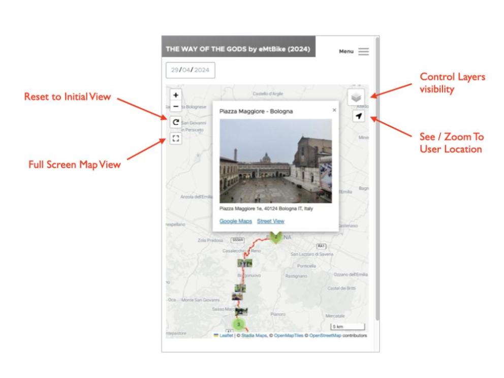
- Interactive Map: Available at https://www.geodemocracy.com/via-degli-dei-2024/web/, the map details the route followed, including start, end, and points of interest. Users can interact with the map to explore different locations and understand the journey’s geographic context.
- Image Gallery: Hosted at https://www.geodemocracy.com/via-degli-dei-2024/web/images, the gallery showcases significant photographic shots, tagged with geolocations to correlate visuals with their precise locations on the route.
The application documents the route followed during my recent E-MTBike trip along the renowned Via degli Dei, traversing the Tuscan-Emilian Apennines in Italy. It highlights the main stages of the journey, including departure, arrival, and various intermediate points of interest, as well as capturing the most significant photographic shots. Additional insights about the Via degli Dei can be found at the following reference links: https://www.viadeglidei.it and https://ecobnb.com/blog/2023/11/via-degli-dei-trekking-bologna-florence/.
Technical Implementation Details:
- GPX Integration: GPX tracks (https://en.wikipedia.org/wiki/GPS_Exchange_Format) are imported and converted into Geofield format using the Geocoder GPX provider.
- EXIF Data Handling: Photographic images' EXIF data (https://en.wikipedia.org/wiki/Exif) including geolocation, is automatically converted into Geofield format via the Geocoder FILE provider.
- Waypoint Generation: Waypoints of interest are created as Geofields using various geometric primitives.
- Enhanced Content Entities: Additional properties such as addresses (via the Address module - https://www.drupal.org/project/address), descriptions, and graphical attributes are associated with content entities.
- Geo-Link Integration: Automatic creation of geo-links to external mapping services like Google Maps and StreetView.
- Date-Based Filtering: Incorporation of date filters for managing content display within the Map and Photo Gallery.
- Media Library Management: Batch import and management of georeferenced photographic images using the Media Library Importer module (https://www.drupal.org/project/media_library_importer).
The Front-End of this application exploits the functionality of the Leaflet module and the high configurability of its Leaflet View Style, through different parameters and controllers, most of which with full token support.
Conclusion
The integration of the Geofield Stack in Drupal for the "Way of the Gods by E-MTBike" project exemplifies the powerful capabilities of web-based GIS tools in enhancing storytelling and user engagement through interactive mapping.
While the "Way of the Gods by E-MTBike" project showcases the Geofield Stack's advanced capabilities, its potential extends far beyond.
With Drupal's inherent flexibility and the collective expertise of its community, users can push the boundaries of what's possible.
The Geofield Stack's continued development owes much to the contributions of its vast user base, whose feedback and engagement drive its evolution. Everyone is encouraged to join in shaping its future through Drupal.org and the Drupal Slack channel (drupal.slack.com).


